
Ouseburn
Some photographs and some words...

…..Ouseburn: if Newcastle upon Tyne had a Shoreditch, this would be it
The Guardian
The Guardian newspaper isn’t the only organisation that has compared the Ouseburn area of Newcastle, about a mile east of the city centre, with London’s Shoreditch, as both districts have undergone a very similar urban transformation. From industrial growth and subsequent decline to becoming artistic and cultural hotspots, although it has to be said that Ouseburn covers a far smaller area. Also, during my years living in the south of England, Shoreditch has become very commercialised and expensive, whereas Ouseburn remains a community-focused, less gentrified area that feels more village-like than urban.
Three years ago, I wrote in Better Damp than Dead of my visit to the Victoria Tunnel, which you now enter in the heart of Ouseburn, which strictly speaking, is the Ouseburn Valley, although everyone here just calls it Ouseburn.
The valley takes its name from the Ouse burn, the River Tyne’s largest tributary and Ouse is a Celtic word for ‘rushing water,’ showing how familiar the waterway was to people in ancient times. There are, in fact, several rivers called the Ouse in England, including the well-known River Ouse in York. Although some people refer to Newcastle’s Ouse as a river, it is technically a burn, starting as a small stream northwest of the city, about a mile north of Walbottle, a village on Hadrian’s Wall. That stream grows as it winds through the wooded valley of Jesmond Dene, then goes underground before reappearing in Ouseburn and finally flows into the Tyne east of Newcastle’s Quayside, about 14 kilometres from its source.
Ouseburn’s initial claim to fame is that it played a significant role in Newcastle’s industrial revolution; some even call it the cradle of that revolution. It was originally part of Byker, which was first recorded in 1198 as a distinct township built outside Newcastle’s city walls. Before the 19th-century industrial boom, the area was mostly farmland, with a few water-powered mills along the Ouse Burn.
As with many place names in Britain, Byker could have a couple of meanings. One is Viking, derived from ‘by kiarr,’ meaning ‘village on the marsh’; if so, it’s one of the very few Viking placenames in Tyneside. However, the words ‘carr’ and ‘kerr’ were also used in northern English after Viking times, so Byker might simply mean ‘next to the marsh,’ since carrs are marshy scrubland. In another of my meanders, I wrote of Byker’s well-known public housing block, the Byker Wall, designed by Ralph Erskine in the early 1970s. Some people in Britain might also remember the children’s TV show Byker Grove, which brought young Ant and Dec to public attention. Interestingly, much of the series' filming took place in Benwell, on the west side of the city. That’s TV magic for you.
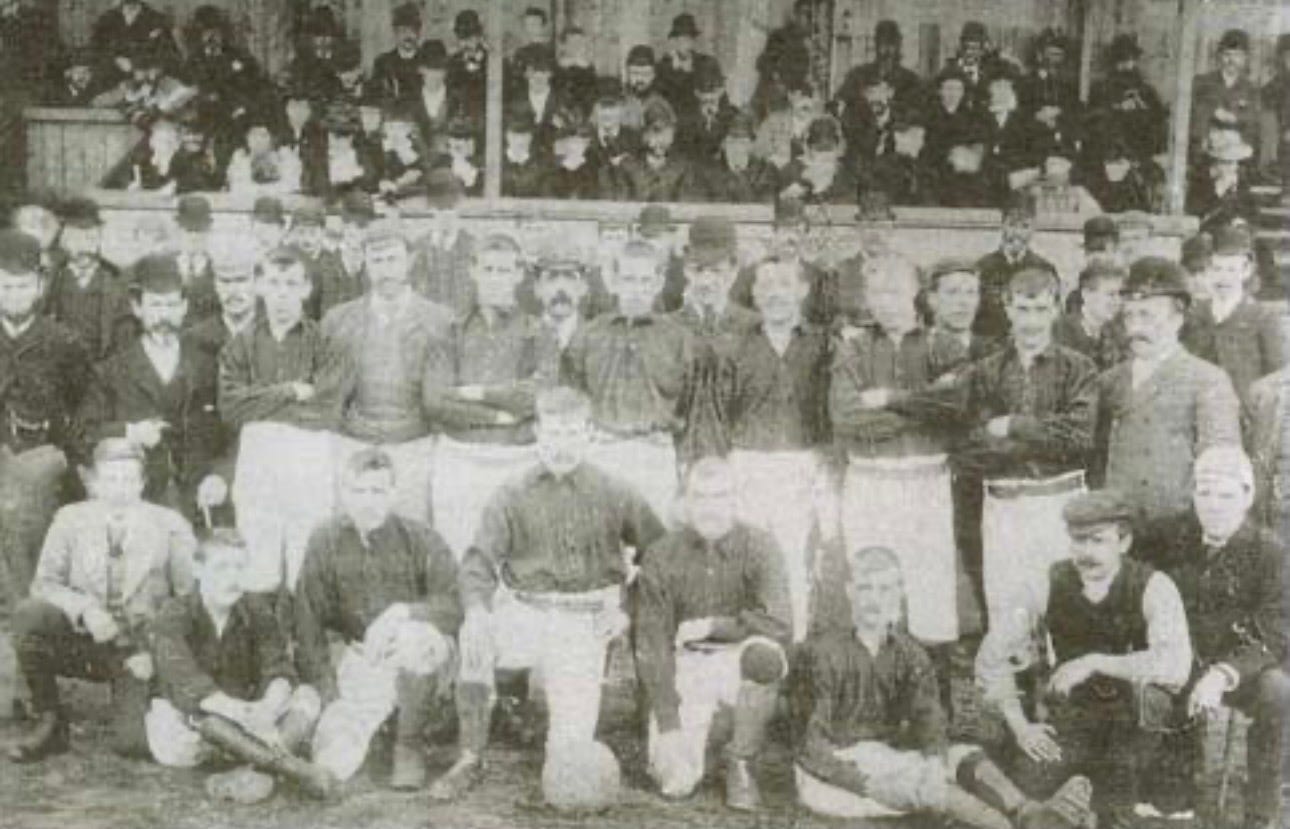
Byker is also where Newcastle United Football Club began as Stanley FC, founded in 1881 by the Stanley Cricket Club to occupy themselves during the winter, with their ground in the Stanley Street area of South Byker. In 1882, a rival Newcastle-based club, West End FC, was founded in Elswick, to the west of Newcastle, and that same year, Stanley FC changed their name to East End FC. Not because of West End FC, but to differentiate themselves from teams from the town of Stanley in County Durham. Over the coming years, East End FC moved around Byker, then in 1886 to Heaton, northeast of Newcastle. East End FC eventually became Newcastle United in 1892 after West End FC went out of business and East End FC took over the lease of West End’s ground, St James’ Park. The new name (the other contenders were Newcastle and Newcastle City) was chosen to attract fans from across Newcastle.
Anyway, enough of that diversion, so let's get back to Ouseburn’s key role in Newcastle’s industrial growth, with the first recorded industry being glassmaking, after three glasshouses were set up in 1619, where the Ouse Burn met the Tyne. This industry eventually led to Newcastle becoming a leading centre for glass production, supplying containers for many industries, especially food and drink, before the widespread use of tin cans for storing perishable food.
Pottery started in the valley in 1782, paving the way for Maling Pottery, one of the most distinctive and successful ceramic manufacturers in northeast England, to open in the following century.
The business actually began in 1762, when Thomas Maling established a pottery on the Newcastle Quayside, producing simple earthenware household wares. Then, in the 1880s, the much-expanded company moved to Ousburn and into a large new factory known as the Ford B Pottery, producing industrial ceramics, especially jam jars, food containers, sanitary ware, and utilitarian pottery. At its peak, this was one of the largest pottery factories in Britain, employing hundreds of workers and producing millions of items annually, blending craft with mass production.
However, Maling is best remembered today for its decorative ceramics, especially from the interwar period in the 1920s and 30s, when the company began producing highly decorative wares that reflected contemporary tastes, with bold, glossy glazes, rich colours, intricate patterns, and transfers, often with an oriental or Art Deco influence.
By this point, Maling pottery was not only sold across Britain but also exported overseas and regarded as both affordable and stylish, occupying a middle ground between mass production and artistic design, making it accessible to a wide audience.
However, after the Second World War, the company faced growing challenges with changing tastes in home décor and competition from cheaper imports, and despite attempts to modernise, the business closed in 1963.
But going back to 19th-century Ousburn, Maling’s move there was soon followed by various industries and businesses, including flax spinning, masonry, lead works, iron foundries, soap makers, tanneries, sawmills, corn mills, flint mills, and coal shipping. The area provided many jobs and became a self-contained community, with terraced housing, tenements, a doctor’s office, a school, and about fifteen pubs or beer houses. The latter became more common after the Beerhouse Act of 1830, which made it easier to open small drinking spots.
In the early 1850s, Scottish engineer Robert Morrison opened the Ouseburn Engine Works that produced a new type of steam hammer for forging iron and steel parts. These hammers could strike with a force of about 125 tons to shape steel plates.
Unfortunately, the works had a troubled history, for example, the Manchester Times reported that on 31st July 1858. “A great sensation was created in the neighbourhood of Ouseburn yesterday morning by a boiler explosion, which occurred a little before six o’clock, at Messrs. R Morrison and Co’s Engine Works. Seven or eight persons were injured, some of them being very seriously scalded. ….. The force of the explosion was tremendous. The boiler went right through the roof of the shed high up into the air, and, clearing some sheer legs, which stood about 35 feet high, it passed over the yard, a distance of many yards, alighting on another shed, smashing through the roof, and penetrating right into a new boiler which lay on the floor….” It wasn’t just accidents; the business also struggled due to financial mismanagement, and after a series of bankruptcies under different owners, the works finally closed for good in 1881.
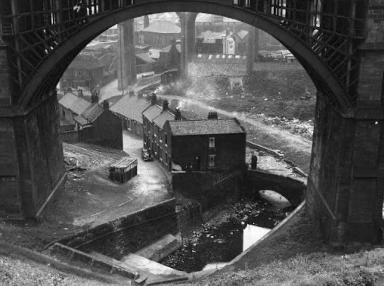
All the industries I’ve mentioned relied on the Ouseburn’s tidal waterway, which allowed boats like keels and later wherries to travel upstream from the River Tyne to bring in raw materials and ship out finished goods to and from tightly packed buildings sitting all along the water’s edge, with slipways, boat supports, loading equipment, mill races, and waterwheels. By the mid-1800s, the valley was a mass of factories, workshops, and workers’ housing, making it one of Newcastle’s first industrial suburbs. The area was lively but crowded, with people living close to heavy, dirty, and often dangerous industry. The lower Ouseburn Valley’s industrial scene was vastly different from that of the upper part, which became home to Victorian parks such as Jesmond Dene, Heaton Park, and Armstrong Park.
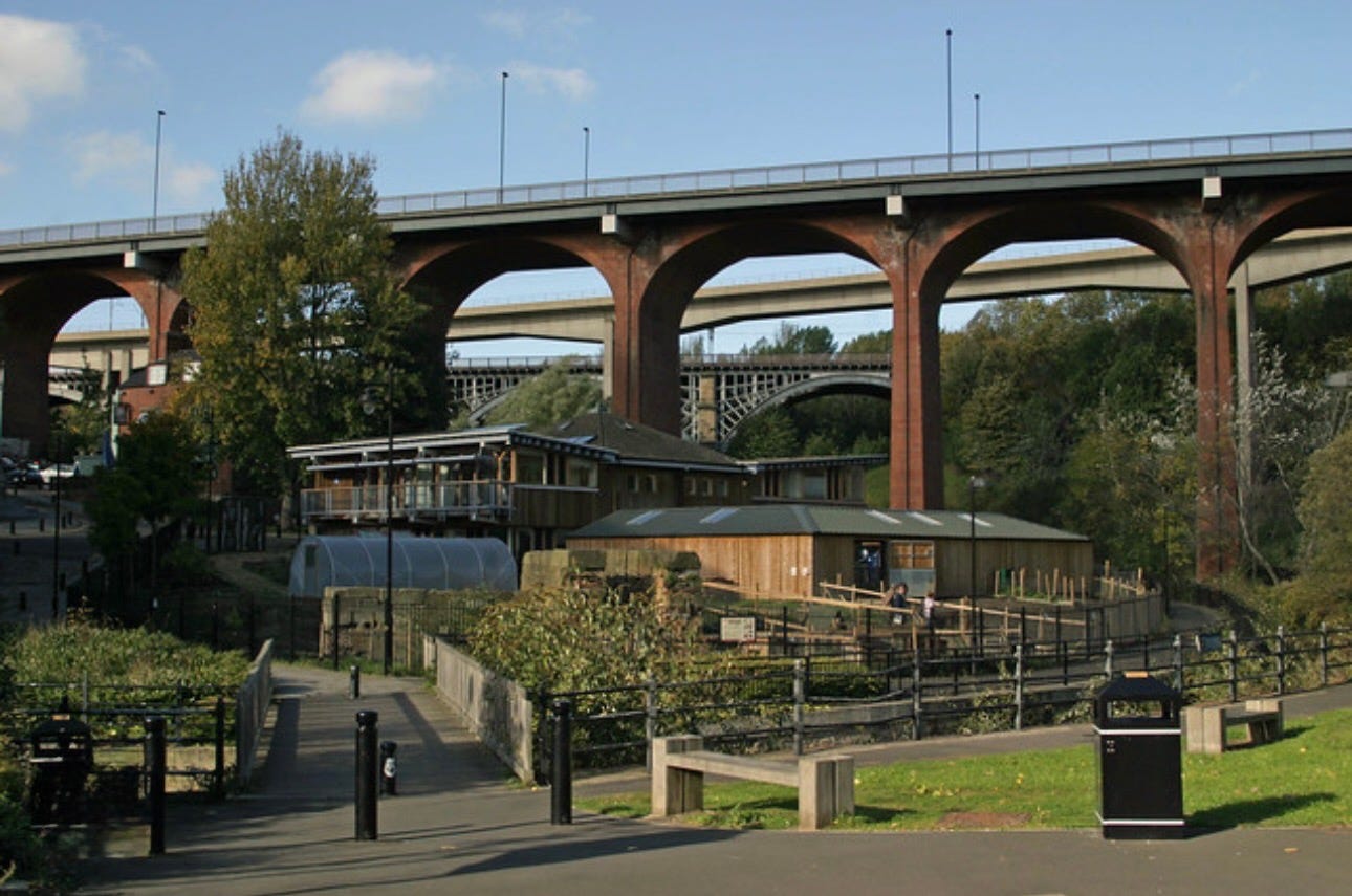
The iron arches of the Ouseburn Viaduct still stand over the valley today. Built in 1869, it replaced an earlier timber bridge from 1839 that carried the first railway from Newcastle to the coastal town of North Shields. The current bridge is about 360 yards (330 meters) long and 108 feet (33 meters) high. Today, it carries the main east coast railway line and is a Grade II listed structure. Nearby is the red brick Byker Bridge, another viaduct built in 1878 as a Victorian road crossing to avoid the steep descent into the valley. There was once a half-penny toll, but that ended in 1895, and the road was widened in 1899 to accommodate trams. No one knows exactly how many bricks were used to build the bridge, but estimates put the number at over 12 million. More recently, in 1986, the deck was rebuilt with modern concrete beams, but the brick-built arches remain. For many years, this was the main eastern road exit from Newcastle. The third bridge, the Byker Viaduct, is much newer than the other two, opening in 1982 for the Tyne and Wear Metro and constructed from pre-cast concrete box-girder sections joined with epoxy resin. It follows an S-shaped curve and even crosses over the top of Byker Road Bridge at one end.
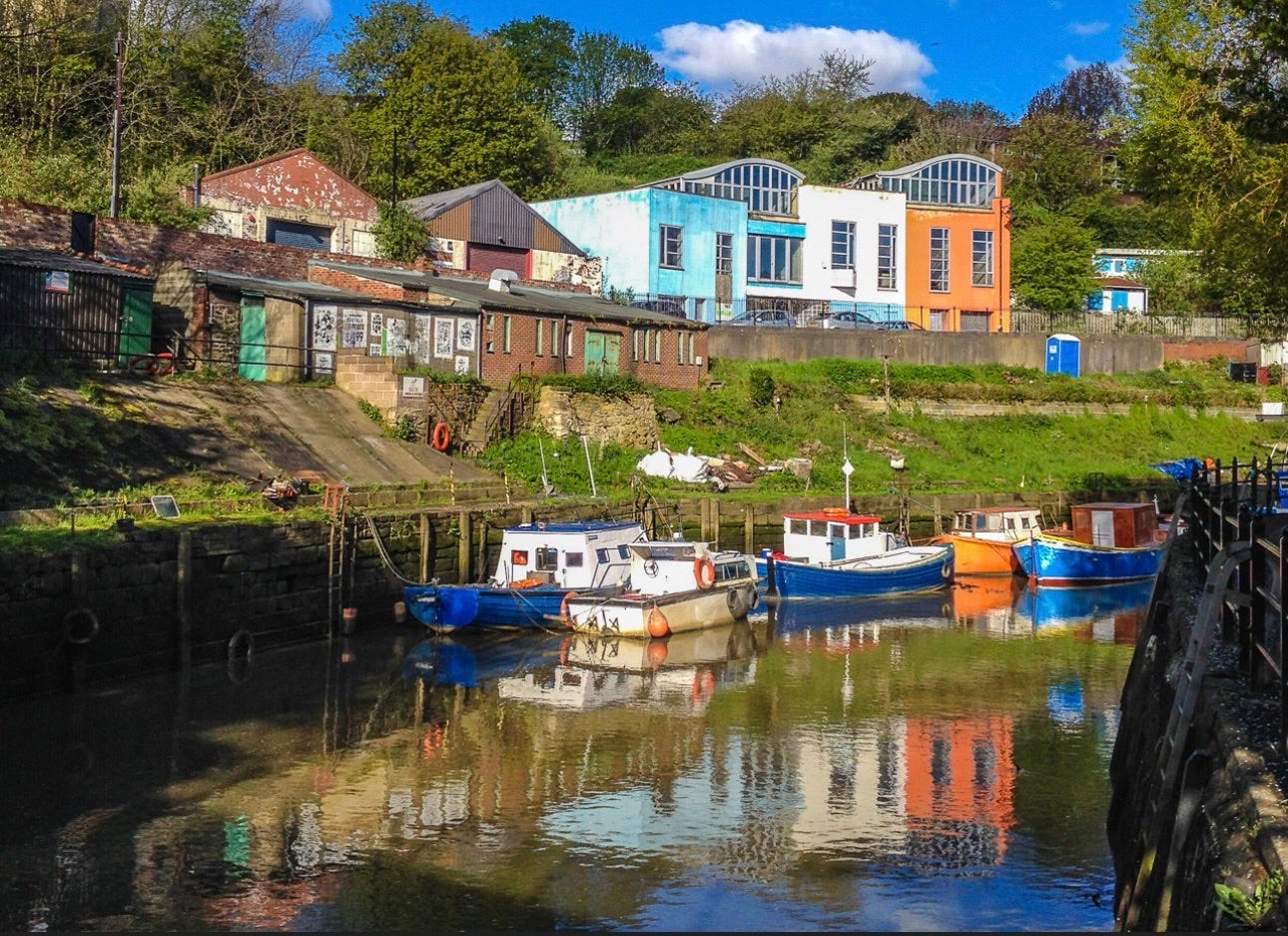
After the Second World War, traditional industries began to collapse across Tyneside. In Ouseburn, many factories closed, and buildings were abandoned, leaving the lower part of the valley as a derelict industrial landscape filled with empty warehouses and decaying infrastructure. Demolition of many buildings took place, but not all, and in the 1970s, artists and musicians began moving into the empty industrial buildings because rents were low. Over time, studios, music venues, galleries, and small creative businesses filled the old factories and warehouses, and in 1996, the creation of the Ouseburn Trust helped guide regeneration and protect the area’s heritage, turning Ouseburn into one of Newcastle’s main arts and creative hubs, with the repurposing of many of its old industrial buildings.
One site near where the Ouseburn meets the Tyne shows how industry in the area changed over time. Until 1868, it was home to corn mills and brickworks, yet just two years later, it became a centre for the unloading of livestock, mainly from Scandinavia, and a sanatorium holding sheep and cattle for health inspection.
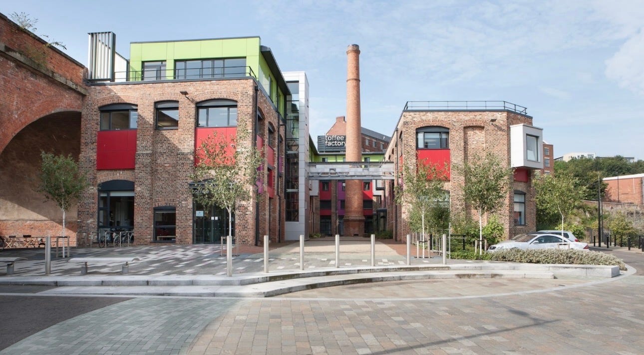
By 1906, the site’s usage changed again when a large part of it became the steam-powered Maynards Toffee Factory, meeting the Victorian demand for sweets. The original Dobson steam engine is gone, but the old chimney still stands as a local landmark. After many years of inactivity, the factory was converted into offices for the arts and crafts community in 2011, with the rest of the site being developed into a multi-storey residential building. The Maynards name lives on through the ‘wine gums’ you can still buy today, although the original company is subsumed into the Mondelez group.
Another example of reuse is a former flax mill built in 1848 that now houses studios and the popular Cluny music venue and bar, which takes its name from the business that operated there, after flax milling ended, producing a blended Scotch whisky of the same name. Yet another is Seven Stories, the national centre for children’s books, opened in 2005 in a nineteenth-century brick flour mill, while nearby, along a bend in the burn that hints at the area’s rural past, is Ouseburn Farm. This urban farm, run by a charity, has goats, sheep, pigs, chickens, and more. Part of the farm’s site was once home to the Northumberland Lead Works, founded in 1871 and later called Walker’s Paint Works because of the white lead paint made there. The works closed in the 1960s, and the land was cleaned of pollutants with new topsoil added. There is also a memorial to the women who suffered lead poisoning while working in the factory.
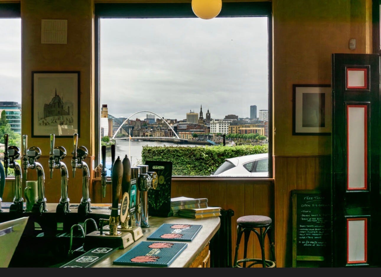
Although the area no longer has 15 pubs, there are still places like the Ship Inn, which was once a house in a Victorian terrace, and there’s also the popular Tyne Bar, originally the old Ship Tavern, dating back to the 1850s, where the Ouseburn meets the Tyne. The Free Trade Inn, from the 18th century, sits high on the bank of the Ouseburn with magnificent views over the Tyne. The area also has its own microbreweries, such as Brinkburn Street Brewery, Kitchen & Bar, which has a basement bar and an outdoor terrace, and the Out There Brewing Company.
Ouseburn is one of the few places in Britain that offer such a clear transformation from industrial centre to creative district within the same historic setting, and this is important because it highlights three major phases of Newcastle’s, and indeed northeast England’s, urban history. First came the industrial rise, with glassworks, engineering, and river trade. Then came industrial decline, leaving the area with vacant buildings and abandoned homes. Finally, creative regeneration brought galleries, music venues, cultural spaces and modern housing.
A wonderful account, Harry. I love to read about industrial history and how an area has gone through changes. It’s good to see that this one is turning around and being alive with activity.