
Corstopitum

"There are two principal races of the Britons, the Caledonians and the Maeatae, and the names of the others have been merged in these two. The Maeatae live next to the cross-wall [Hadrian’s Wall] which cuts the island in half, and the Caledonians are beyond them. Both tribes inhabit wild and waterless mountains and desolate and swampy plains, and possess neither walls, cities, nor tilled fields, but live on their flocks, wild game, and certain fruits...They dwell in tents, naked and unshod, possess their women in common, and in common rear all the offspring. Their form of rule is democratic for the most part, and they are very fond of plundering; consequently they choose their boldest men as rulers....They can endure hunger and cold and any kind of hardship; for they plunge into the swamps and exist there for many days with only their heads above water, and in the forests they support themselves upon bark and roots, and for all emergencies they prepare a certain kind of food, the eating of a small portion of which, the size of a bean, prevents them from feeling either hunger or thirst.”
Cassius Dio writes of Septimius Severus' campaign of 209 CE in northern Britain and the tribes there of whom he thought a formidable adversary.
A couple of weeks back, I wrote about my visit to the Life in the Roman Legion Exhibition in London’s British Museum. Last week, I travelled a few miles west from my home in Blaydon to see what still exists of what was once the largest and most northern English Roman town, and indeed the most northern town of the Roman Empire, Corstopitum.
Nestling by the north bank of the River Tyne, a short walk from the small and beautiful Northumbrian town of Corbridge, Corstopitum was once a bustling Roman settlement and strategic military outpost. Now an archaeological site, the digs at Corstopitum have provided a treasure trove of insights into the life and culture of ancient Rome beyond the imperial heartland.
Around 77CE, Julius Agricola, the then-Roman Governor of Britain, ordered the building of a Roman fort and administrative centre at one of the lowest fordable points of the River Tyne, thus affording control of the river crossing. However, there is evidence of the abandoning of the fort around nine years later, perhaps due to flooding and a new fort, Corstopitum, was built, near where the important Roman road Dere Street crossed the River Tyne and intersected another significant Roman Road that today we call the Stanegate (the stone-paved way).
Dere Street, known in Latin as 'Via Devana', took its name from the Roman fort of Deva (modern-day Chester) and formed part of a broader network of military highways designed to aid the movement of troops, supplies, and administrators across the province of Britannia.
Constructed with meticulous precision and engineering ingenuity, Dere Street traversed some of the most challenging terrain in the country, including rugged hills, dense forests, and marshy lowlands. The road held immense strategic significance for the Roman military machine as a critical thoroughfare connecting the Roman northern frontier with the provincial capital of Eboracum (modern-day York) and onwards south. Beyond its military function, Dere Street also played a pivotal role in developing commercial and cultural exchange throughout Britannia. Along its route, bustling settlements, market towns, and trading posts sprang up as hubs of commercial and economic activity and social interaction. Merchants, travellers, and artisans from across the Roman empire travelled along Dere Street, bringing with them goods, customs, and ideas that enriched the cultural tapestry of Roman Britain. The road became a conduit for the dissemination of Romanitas – the distinctive cultural identity and values of the Roman world – leaving an indelible mark on the landscape and society of Britannia.
Both built before Hadrian's Wall, Dere Street aided movement north and south while Stanegate ran east-west along the Tyne Valley between Corstopitum and Luguvalium (modern-day Carlisle). As with Dere Street, Stanegate became a vital artery of communication and control in aiding the movement of troops and supplies across the northern frontier province of Britannia, thus bolstering Roman authority. Until the building of Hadrian's Wall, Stanegate marked the northernmost border of the Roman advance into Britannia and allowed Roman legions to keep a robust military presence along the frontier, deterring potential threats from hostile tribes by allowing for the rapid deployment of troops and the efficient movement of supplies, enabling Roman forces to respond swiftly to incursions or unrest in the region.
The second Roman fort at Corstopitum burned down around 105CE, and its replacement, after the building of Hadrian's Wall some twenty years later, lay within the protection of the wall from the north, with the River Tyne protecting the fort from attack from the south. With its strategic location at the intersection of major roads linking the Roman frontier with the hinterlands of northern Britain, Corstopitum became a hub of commerce, communication, and cultural exchange.
The arrival of a new Emperor, Antonius Pius, and his plan to conquer what was then known as Caledonia and what we know as Scotland led to the rapid expansion of Corstopitum. The emperor initially succeeded in his conquering endeavours and built a new wall between modern-day Glasgow and Edinburgh. Alas, the Antonine Wall proved short-lived for Pius. Still, the campaign expanded Corstopitum rapidly, allowing it to become a significant military base and agricultural supply centre.
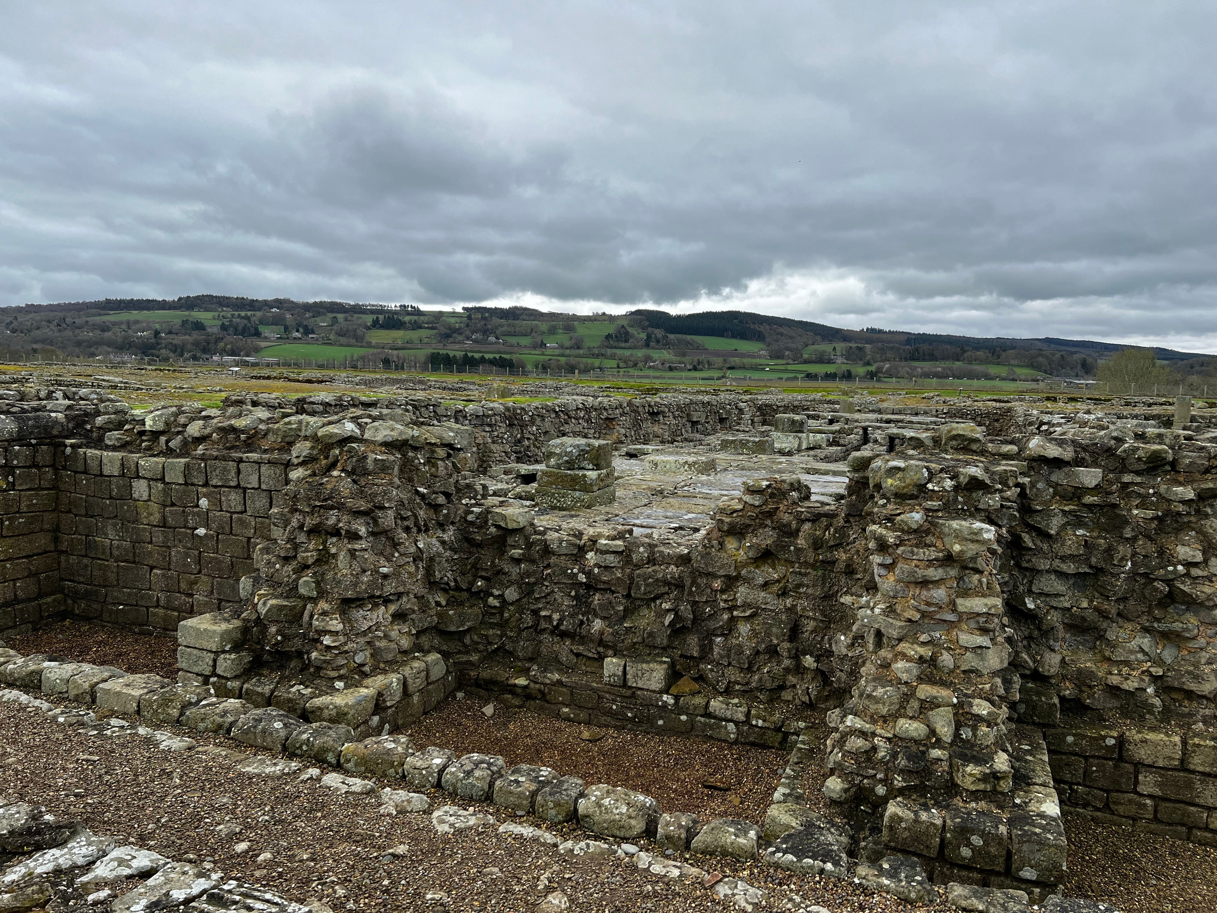
After the Romans abandoned the Antonine Wall around 160CE, Corstopitum developed into a legionary base, a substantial supply base, and a centre for granaries and warehouses serving the whole eastern half of Hadrian's Wall and forts beyond the frontier to the north. However, the civilian population appeared to have as much influence in the town as the military. The archaeological evidence shows that the military compound does not follow the usual 'playing card' shape in wholly military establishments. Its construction is ‘moulded’ around civilian buildings, a compromise between the civilian buildings and barracks. Clearly, Corstopitum was just as important to trade and home to tradespeople and merchants as much as the soldiers stationed in the military compound. In fact, by the early 200s CE, Corstopitum was becoming increasingly civilian, boasting an array of public buildings, temples, forums, and private residences that reflected the cosmopolitan character of urban life in the Roman Empire.
Visiting today, and while it can't boast the quality of buildings discovered at, say, Pompeii or Herculaneum, there is still an impressive array of architectural remains at the site that offer tantalising glimpses into Corstopitum's former glory. The remains of a substantial Roman fort, complete with defensive walls, barracks, and administrative buildings, attest to Corstopitum's strategic importance as a military stronghold. In contrast, nearby, the remains of a civilian settlement reveal the everyday lives of Corstopitum's civilian inhabitants, with evidence of workshops, shops, and townhouses providing insights into Roman provincial life's economic and social dynamics.

Archaeological finds such as altars, votive offerings, and inscriptions bear witness to the spiritual beliefs and practices of Corstopitum's inhabitants, offering valuable clues to their worldview and social identity. Corstopitum appears as a melting pot of cultures and peoples from the Roman world and a vibrant centre of cultural and religious exchange. Temples dedicated to Roman deities such as Jupiter, Mars, and Minerva coexisted alongside shrines honouring indigenous Celtic gods, reflecting the syncretic nature of Roman religion in Britain. Also uncovered is an altar dedicated to the cult of Mithras, a mystery religion popular among Roman soldiers. The altar, adorned with intricate carvings and inscriptions, attests to the religious diversity within Roman Britain.
Given Corstopitum's size and importance, it's no surprise that archaeologists have made some incredible finds there. One of the most significant is the 'Corbridge Hoard', a collection of Roman military equipment and personal belongings dating from the second century. The hoard includes items such as armour, weapons, tools, and personal items, offering a rare glimpse into the life of Roman soldiers stationed at Corstopitum.
Given the nearby Hadrian's Wall, it's also no surprise that many Hadrianic inscriptions in Corstopitum date to that emperor's reign. These include dedicatory plaques and building inscriptions that provide valuable information about the construction and maintenance of public buildings and infrastructure in the settlement. Excavations also yielded a wide range of pottery and glassware, including amphorae, jars, bowls, and drinking vessels. These artefacts offer insights into Roman trade networks, dietary habits, and social customs. Finds also include many Roman coins spanning more than three hundred years of Roman occupation in Britain. These coins provide valuable evidence of economic activity, currency circulation, and regional political developments.
Archaeologists also found several funerary monuments, two of which poignantly commemorated young children. Both memorials had sculptures of the children and tender messages. Their condition suggests that their decoration was once colourful.

Also colourfully decorated, as you can see from my photograph, is a copy of a Roman soldier’s funerary monument. The original is in Hexham Abbey. The memorial shows a standard-bearer in the Roman cavalry riding down a 'barbarian' (as described by Cassius Dio in the quotation at the start of this piece) - probably from north of the border. The memorial inscription shows it to commemorate Flavinus, an officer in the Ala Petriana, stationed at Corstopitum, who died aged twenty-five after seven years of service. The belief is that the slab dates to the late first century and once stood in the military cemetery near the fort. Ala Petriana took its name from Titus Pomponius Petra, who was probably the unit's original commander shortly after it was raised from the tribes of central Gaul (now northern France).
Despite the monument’s bright colours, it is a chilling reminder of the Roman Empire's brutal colonisation of Britain.
However, despite its prosperity and prominence, Roman Corstopitum eventually declined in the fourth century as the Roman Empire grappled with external threats, internal strife, and economic challenges. The gradual withdrawal of Roman forces from Britain and the later Anglo-Saxon invasions hastened the town's demise, leading to its eventual abandonment and decline into obscurity. And yet, the Anglo-Saxons also saw the strategic value of the area. The Angles built the settlement of Corbridge, only a long stone's throw east of Corstopitum, to serve as one of their capitals of Northumbria. They used stones from the neighbouring Roman site as building material at Corbridge. And I've shared before in From Angles to Jacobites that some of the stones from Corstopitum even found their way to the nearby town of Hexham and used to build the abbey there. Recycling began a long time ago …..
I've been seeking out a bit of classical education recently so this was a good introduction into some of our Roman history! Interesting mention of Chester as well; that's where my grandparents live and I had no idea about that little piece of Chester history that you touched on so I shall mention that the next time I'm up there. Sounds like an interesting wander, Harry. I might take a little escapade up to Corstopitum myself to have a look at the ruins etc. Has anyone ever told you that you should write for history books and magazines? Being able to eloquently write accounts of history is a very specific skill and not something all writers can do (I'm not convinced I still can!), but you really do make it look effortless.
Thanks, Harry! Sounds like a very interesting meander, thanks for writing about it!